
Modern versions of QGIS comes with a handy command-line utility called qgis_process. This allows you to access and run any Processing Tool, Script or Model from the Processing Toolbox on a terminal. This is very useful for automation since it doesn’t require you to open QGIS or manually click buttons. You can run the algorithms in a headless-mode and even schedule them to run them at specific times.
This post covers the following topics
- How to launch qgis_process command on Windows, Mac and Linux.
- How to find the parameters and values for each algorithm and build your command
- Example showing how to do a spatial join on the command-line using the Join Attributes by Location algorithm
- Example showing how to run a model on the command line to automate a complex workflow
Want to follow along? You can download the data package containing all the datasets used in this post. Before running each command, make sure to replace the paths in the commands with the paths on your computer.
Running the qgis_process Command
Windows
If you have installed QGIS via the OSGeo4W installer, your installation already has the qgis_process command. The installation comes with a .bat file that will set the correct environment variables and run the command.
For the QGIS LTR version, the .bat file is located at
c:\OSGeo4W\bin\qgis_process-qgis-ltr.bat
If you are running a non-LTR version, the script will be at the following location.
c:\OSGeo4W\bin\qgis_process-qgis.bat
For this post, we will be using the LTR version. If you have a different version, change your path in the commands accordingly.
Open the Command Prompt from the Start menu and enter the full path to the .bat file. Press Enter. You will see the command options and help printed in the console. If you see help printed – it means you are able to successfully launch the command.

Mac
QGIS Mac installers also come with the qgis_process utility. But to launch it, you have to specify the full path to it.
For the QGIS LTR version, the command is located at
/Applications/QGIS-LTR.app/Contents/MacOS/qgis_process
If you are running a non-LTR version, the command will be at the following location.
/Applications/QGIS.app/Contents/MacOS/qgis_process
You can open the Terminal and enter the command as below

Linux
This will depend on your distribution, but on most Linux versions, you will have the qgis_process utility in your system path and can be launched directly from a terminal.
qgis_process

Building Your Command
The qgis_process command has the following syntax to run an algorithm.
qgis_process run <id of the algorithm or path to model> <parameters>
The easiest way to find the id and parameters of a Processing Algorithm is to first run it from the QGIS application. This will allow you to find the parameters and their values without digging through the documentation.
Let’s do a spatial join between 2 vector layers. We will carry out the Spatial Join Analysis covered in my Advanced QGIS course. Here are the steps to do this in QGIS. We will later replicate this using the qgis_process command.
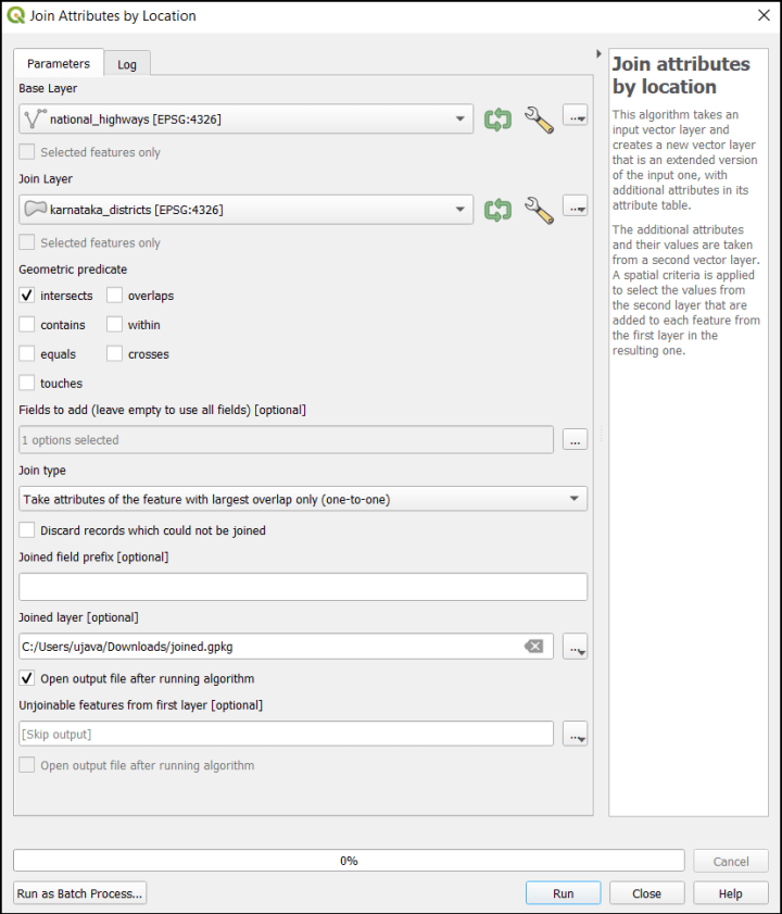
We want to join the karnataka_district polygon layer with the national_highways line layer using the Join attributes by location algorithm.

You can configure the tool and click Run.
If you are using QGIS 3.24 or higher, you can now copy the command directly from the Advanced tab at the bottom of the processing dialog.

For QGIS 3.22 or older version, you can find the parameters from the Processing History. Run the algorithm and once the processing finishes, go to Processing → History.
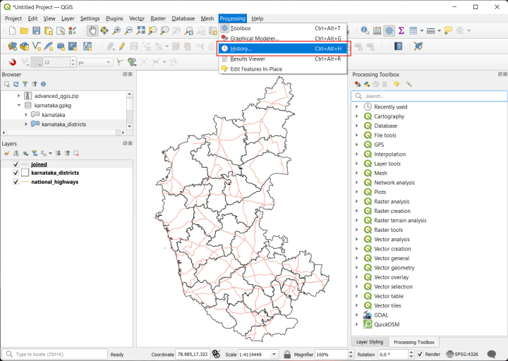
The first row will the last command you ran. Click on the command and you will see the algorithm id and the parameters used. You now have all the information to run this tool from the command line.

We can now build the command to run qgis_process. From the output shown in the Processing History, we can see that the id of the algorithm is native:joinattributesbylocation. For each parameter, we have the parameter name and its value. Keep the following in mind when using the values displayed in building the command
- Each parameter has to be specified as a command-line flag. i.e.
INPUTbecomes--INPUT. - If the value is a list, it has to be specified with a comma-separated value. i.e.
[1,2]becomes1,2 - True/False values have to be specified as as integers. i.e.
Yes/Truebecomes1andNo/Falsebecomes0
You can learn more about the parameters and values accepted by any algorithm by running the help command like below.
c:\OSGeo4W\bin\qgis_process-qgis-ltr.bat help native:joinattributesbylocation

Example: Spatial Join on the Command Line
Now let’s run the spatial join using the qgis_process command. From the previous section, we already know the algorithm id and the parameters. The full command is shown below.
Windows
The command below is suitable to run on Windows Command Prompt. Since the command is very long, we can use the line continuation character (^) to break it down over multiple lines.
c:\OSGeo4W\bin\qgis_process-qgis-ltr.bat run ^
native:joinattributesbylocation ^
--INPUT="C:/Users/ujava/Downloads/karnataka.gpkg|layername=national_highways" ^
--JOIN="C:/Users/ujava/Downloads/karnataka.gpkg|layername=karnataka_districts" ^
--PREDICATE=0 ^
--JOIN_FIELDS=DISTRICT ^
--METHOD=2 ^
--DISCARD_NONMATCHING=0 ^
--PREFIX="" ^
--OUTPUT="C:/Users/ujava/Downloads/joined.gpkg"
Run the command and qgis_process will carry out the processing. Once the command is finished, a new geopackage layer is created with the result of the spatial join.

Mac
If you are on a Mac, below is the equivalent command to do the spatial join. We use the appropriate data paths and use line continuation character (\).
/Applications/QGIS-LTR.app/Contents/MacOS/bin/qgis_process \
run \
native:joinattributesbylocation \
--INPUT="/Users/ujavalgandhi/Downloads/karnataka.gpkg|layername=national_highways" \
--JOIN="/Users/ujavalgandhi/Downloads/karnataka.gpkg|layername=karnataka_districts" \
--PREDICATE=0 \
--JOIN_FIELDS=DISTRICT \
--METHOD=2 \
--DISCARD_NONMATCHING=0 \
--PREFIX="" \
--OUTPUT="/Users/ujavalgandhi/Downloads/joined.gpkg"
Linux
Linux command is similar to Mac but we use appropriate data and program paths
qgis_process \
run \
native:joinattributesbylocation \
--INPUT="/home/ujaval/Downloads/karnataka.gpkg|layername=national_highways" \
--JOIN="/home/ujaval/Downloads/karnataka.gpkg|layername=karnataka_districts" \
--PREDICATE=0 \
--JOIN_FIELDS=DISTRICT \
--METHOD=2 \
--DISCARD_NONMATCHING=0 \
--PREFIX="" \
--OUTPUT="/home/ujaval/Downloads/joined.gpkg"
Example: Running a Model on the Command Line
qgis_process can also run a model from the command-line. This is very helpful where you have a created a model in the QGIS Modeler and want to automate running the workflow.
We will take the example model for Aggregating Piracy Incidents from my Advanced QGIS course and see how it can be run from the command line. The QGIS models are saved as a .model file and the data package contains the piracy_hexbin.model3 file that can be used to run the command.
We first use the help command to find out the required parameters.
c:\OSGeo4W\bin\qgis_process-qgis-ltr.bat help ^ c:/Users/ujava/Downloads/piracy_hexbin.model3

Note that the model uses the Project CRS defined in a QGIS Project. qgis_process command also has an option --PROJECT_PATH to specify a project file which will be used when the model is executed. The example project file is also included in the data package. Using this information, we can now build the command using the parameters and run it like below.
c:\OSGeo4W\bin\qgis_process-qgis-ltr.bat run ^
c:/Users/ujava/Downloads/piracy_hexbin.model3 ^
--baselayer="C:/Users/ujava/Downloads/maritime_piracy.gpkg|layername=ne_10m_land"
--inputpoints="C:/Users/ujava/Downloads/maritime_piracy.gpkg|layername=ASAM_events"
--gridsize=250000
--native:countpointsinpolygon_1:Aggregated="C:/Users/ujava/Downloads/counts.gpkg"
--PROJECT_PATH="C:/Users/ujava/Downloads/maritime_piracy.qgz"

You will see that the model executed 5 algorithms and processed the inputs into an output layer.
Mac
The same model can be run on a mac with the following syntax.
/Applications/QGIS-LTR.app/Contents/MacOS/bin/qgis_process run \
/Users/ujavalgandhi/Downloads/piracy_hexbin.model3 \
--baselayer="/Users/ujavalgandhi/Downloads/maritime_piracy.gpkg|layername=ne_10m_land" \
--inputpoints="/Users/ujavalgandhi/Downloads/maritime_piracy.gpkg|layername=ASAM_events" \
--gridsize=250000 \
--native:countpointsinpolygon_1:Aggregated="/Users/ujavalgandhi/Downloads/counts.gpkg" \
--PROJECT_PATH="/Users/ujavalgandhi/Downloads/maritime_piracy.qgz"
Linux
On a linux system, the model can be invoked with a similar command.
qgis_process run \
/home/ujaval/Downloads/piracy_hexbin.model3 \
--baselayer="/home/ujaval/Downloads/maritime_piracy.gpkg|layername=ne_10m_land" \
--inputpoints="/home/ujaval/Downloads/maritime_piracy.gpkg|layername=ASAM_events" \
--gridsize=250000 \
--native:countpointsinpolygon_1:Aggregated="/home/ujaval/Downloads/counts.gpkg" \
--PROJECT_PATH="/home/ujaval/Downloads/maritime_piracy.qgz"
Caveats: Specifying Complex Parameter List as JSON
There are some tools whose parameters can be quite complex and cannot be specified directly on the command line. For example, the Aggregate algorithm – which allows you to calculate various group statistics while merging the features – has many parameters which are difficult to specify on the command line. The easiest way to run such algorithms on the command line is to first configure them using the algorithm in QGIS. Once configured, the algorithm will generate the required command for you. But in some cases, if you try to configure the tool and then select Advanced → Copy as qgis_process command, you will get an error Current settings cannot be specified as arguments to qgis_process (Pipe parameters as JSON to qgis_process instead). This means, we need to instead use Advanced → Copy as JSON.

Once the configuration is copied as JSON, paste it in a text editor and save it as a file on your computer. Here we save it as a file named parameters.json (note there is no .txt at the end).

Now we can run the algorithm on the command line using the saved configuration. As mentioned in the QGIS Documentation, you need to “Pipe” the JSON as an input to the command and use “-” character in the command line. The syntax will depend on the operating system.
Windows
Use the type command to read the saved file and pipe the input to the command
type parameters.json | c:\OSGeo4W\bin\qgis_process-qgis-ltr.bat run ^
 "native:aggregate" -
The command will run and generate the desired output. (You can ingore the warnings).

Mac
On Mac and Linux-based systems, use the cat command to read the file and pipe the output to the command.
cat parameters.json | /Applications/QGIS-LTR.app/Contents/MacOS/bin/qgis_process run \
 "native:aggregate" -
Linux
cat parameters.json | qgis_process run "native:aggregate" -
The qgis_process is a welcome addition to your GIS-toolkit. As you move towards automation, this little tool fills an important gap that allows you to automate your workflows. If you found this post helpful and end up using this tool in your work – please let me know in the comments!
[…] https://spatialthoughts.com/2022/07/30/qgis_process_command_line/ […]
Thanks so much for your article, really helpful
Thank you very much for this helpful tutorial!
I do have a question, though, regarding the error/warning that keeps popping up during execution in the command prompt. It reads: “ERROR 1: PROJ: proj_create_from_database: C:\OSGeo4W\share\proj\proj.db contains DATABASE.LAYOUT.VERSION.MINOR = 1 whereas a number >= 2 is expected. It comes from another PROJ installation.” I tried to reinstall PROJ through OSGeo4W (https://proj.org/install.html) but to no avail. The OSGeo4W interface told me to do a “fresh install”, the meaning of which I’m not sure of. I’d greatly appreciate any advice on rectifying this issue.
Please see our un-install guide for doing a clean install https://courses.spatialthoughts.com/uninstall-qgis-ltr.html
Very helpful, thank you!
[…] to level up your QGIS Automation skills? Check out our post on how to run QGIS Processing Algorithms and Models from the command line and watch the video demonstration of automating QGIS workflows […]
Very good article, thanks!
I have got one problem running the tool “native:aggregate” for the “AGGREGATES” input. In QGIS it works but I dont understand how to translate what it seems a list of parameters and i get always error “ERROR: An error was encountered while checking parameter values Incorrect parameter value for AGGREGATES”. For example in qgis I have:
processing.run(“native:aggregate”, {‘INPUT’:’C:/Test/input.gpkg|layername=input|geometrytype=Point25D’,’GROUP_BY’:’array(“missionid”,”aoiname”)’,’AGGREGATES’:[{‘aggregate’: ‘first_value’,’delimiter’: ‘,’,’input’: ‘”missionid”‘,’length’: 0,’name’: ‘missionid’,’precision’: 0,’type’: 10}],’OUTPUT’:’C:/Test/output.xlsx’})
Thanks!
Thanks for the report. In this case you need to use JSON and pipe the parameters to the command. I have updated the post with a new section and detailed instructions. I also tested the
native:aggregatealgorithm and with the specified method, it runs successfully on the command line. Please do try and let me know if it works for you.